Tahquamenon Falls Hiking: Routes & Tips
Tahquamenon Falls State Park has more than 35 miles of trails, but a lot of the mileage and difficulty info floating around — including some of our own older numbers — doesn’t match current trail data. This guide gives you verified distances for every named trail, plus which ones work for beginners, families, or a serious day hike.
Wandering Michigan Wisconsin contains affiliate links. If you make a purchase using one of the links below, we may receive compensation at no extra cost to you. We only recommend products and services we use and trust.
Read our disclaimer for more information.
A note on how this guide is built: every distance and difficulty rating here is checked against current trail data and official park sources — not copied from older articles that turned out to have outdated numbers, as you’ll see below. I hike with stability poles myself, so accessibility and real footing conditions get particular attention throughout. [Have a question about a trail I haven’t covered in enough depth? Reach out — I read every message.]
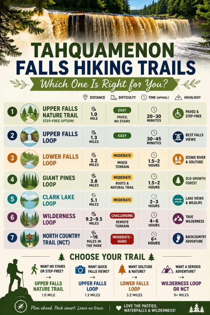
Tahquamenon Falls Trails
Upper Falls Loop
1.3 miles | Easy | ~30–45 minutes | Mostly paved with stairs
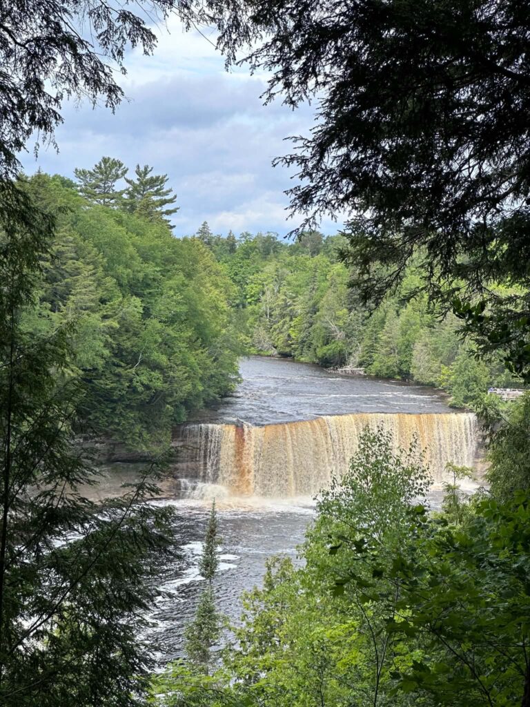
The most popular trail in the park, and for good reason — it delivers the falls views most people come for without a serious time commitment. Most of the route is paved, though it includes stairs along the way, so it’s not a step-free option (see the Nature Trail below for that). Dogs are welcome on leash.
Upper Falls Nature Trail
1.0 mile out-and-back | Easy | ~20 minutes | Paved, no stairs
This is the step-free alternative to the Upper Falls Loop, connecting to the same trailhead area. It skips the stairs, making it the better choice if you want falls views without navigating steps. Good for birding in summer, and stroller-friendly.
Lower Falls Loop
3.2 miles | Moderate | ~1 hour 7 minutes | Mixed terrain
Circles the Lower Falls area, generally quieter and less crowded than the Upper Falls trails. Expect muddy patches near the riverbank — hiking poles help if you use them.

Giant Pines Loop
3.8 miles | Moderate
Winds through hemlock forest past two of Michigan’s largest white pine trees, both dating to the 1800s. This trail doubles as a groomed cross-country ski route in winter.

Clark Lake Loop
5.1 miles | Moderate | ~1 hour 35 minutes
A quieter route through pine forest and mossy lowlands, with blueberry patches in season and views of Clark Lake. Connects to the Wilderness Loop for a longer combined hike. For groomed routes and other winter trail options in the park, see Tahquamenon Falls Winter. The Clark lake picnic area is only for hikers with a permit at the specific campsite.
Before You Go: The Clark Lake Loop begins at a parking area on Clark Lake Road, southwest of Paradise. Although the loop is listed as a moderate hike, reaching the lake may involve 1-2 miles of walking each way. Expect natural backcountry conditions, including loose sand, exposed roots, mud, and uneven ground. Hikers who rely on a cane, walker, or wheelchair should choose one of the park’s more accessible trails instead.

Wilderness Loop
9.2–9.5 miles (sources vary slightly) | Challenging
A primitive trail through old-growth hemlock and pine ridges, crossing peatlands as it goes – the most remote hiking the park offers, passing a beaver pond along the way. This is a real commitment, not a casual afternoon add-on.
North Country Trail (Tahquamenon Falls to Emerson)
20.3 miles one-way | Moderate | 7–7.5 hours
The longest, most demanding hike connected to the park, running from Tahquamenon Falls to the abandoned town of Emerson. Within the park boundary, the North Country Trail covers about 16 miles, including a route connecting the Upper and Lower Falls. Most hikers choose a section rather than the full point-to-point route – reasonable, since this is a real backcountry commitment requiring a transportation plan for the one-way trip. Expect exposed roots and inconsistent signage in places; solid footwear matters more here than on the shorter, more developed trails.
Trail Comparison at a Glance
| Trail | Distance | Difficulty | Best For |
|---|---|---|---|
| Upper Falls Nature Trail | 1.0 mi | Easy | Step-free, families, birding |
| Upper Falls Loop | 1.3 mi | Easy | First-time visitors, quick falls views |
| Lower Falls Loop | 3.2 mi | Moderate | Fewer crowds, more solitude |
| Giant Pines Loop | 3.8 mi | Moderate | Old-growth forest, winter skiing |
| Clark Lake Loop | 5.1 mi | Moderate | Quiet, lake views, blueberries in season |
| Wilderness Loop | 9.2–9.5 mi | Challenging | Serious hikers wanting remote terrain |
| North Country Trail (in-park) | ~16 mi | Moderate–Hard | Backcountry, multi-hour commitment |
Safety and Wildlife
This is real backcountry in places, and a few things are worth knowing before you go – not to alarm you, but because most guides to this park skip it.
Bears: black bears live throughout the park and are active near trailheads and campgrounds, though sightings on the main viewing trails are uncommon. Store food and scented items in a hard-sided vehicle rather than a tent or backpack left on the ground. If you do encounter one on a trail, give it space and back away – don’t run.
Moose: more common in recent years, most often spotted in wet areas along M-123 between Paradise and the Lower Falls, especially around dawn and dusk. Keep your distance; a moose is a large animal and can turn unpredictable if it feels crowded.
Snakes: good news here – the Upper Peninsula has no venomous snakes. Michigan’s only venomous species, the eastern massasauga rattlesnake, is confined to the Lower Peninsula. Nonvenomous snakes may still turn up in warm, sunny spots, so it’s worth watching where you place your hands and feet around rocky areas.
Navigation: the North Country Trail is marked with blue blazes, but signage can be inconsistent in places. Download an offline map (AllTrails’ offline feature works well) before a longer hike, since cell service is unreliable throughout the park – don’t count on real-time GPS.
In an emergency: the park office can be reached at (906) 492-3415. The nearest hospital is Helen Newberry Joy Hospital in Newberry, about 35 miles from the park. If you’re heading out on the Wilderness Loop or a long North Country Trail section, tell someone your planned route and expected return time before you start.
Accessibility Notes
Mobility: Start with the comparison table above – distance and difficulty are the first filter for any accessibility need. The Upper Falls Nature Trail is your best step-free option at the park, paved throughout. The Upper Falls Loop is mostly paved but includes stairs, so it’s not step-free despite being short. For the complete accessibility breakdown – track chairs and the Lower Falls island bridge – see Tahquamenon Falls: What’s Actually Accessible.
Vision: Exposed roots and inconsistent trail signage on the North Country Trail are worth knowing about in advance – this isn’t a trail with reliable, frequent markers the way the shorter loops are.
Hearing: No posted audio trail information anywhere in the park; navigation relies on visual signage and trail blazes instead of any audio system.
Sensory: The Upper Falls Loop is the busiest, loudest trail in the park during peak season. The Wilderness Loop and North Country Trail sections offer real solitude if crowds and noise are a concern — a genuine tradeoff against their much greater physical demands.
Hiking with Dogs
Dogs are welcome on leash throughout most of these trails. For a full breakdown of which trail fits which kind of dog – plus real hazards like ticks and what’s off-limits – see Tahquamenon Falls with Dogs.
What to Pack
- Sturdy hiking shoes — the Lower Falls area gets muddy, and the North Country Trail has exposed roots
- Bug spray — mosquitoes and black flies are a real presence near the river corridors, worst in late spring through early summer
- Trekking poles if you use them — useful on the Lower Falls Loop’s muddier sections
- A trail map or offline map download — cell service is limited throughout the park, and signage on the longer trails isn’t always reliable
Tahquamenon Falls Hiking: FAQ
The Upper Falls Nature Trail (1.0 mile, paved, no stairs) is the easiest and most accessible option. The Upper Falls Loop (1.3 miles) is nearly as easy but includes stairs.
It depends which falls and which trail. The Upper Falls Loop is 1.3 miles round-trip from the main parking area. The Lower Falls Loop is 3.2 miles. The full North Country Trail connection between both falls runs closer to 4 miles one-way.
The main viewing trails (Upper Falls Loop, Nature Trail, Lower Falls Loop) are easy to moderate and suitable for most fitness levels. The Wilderness Loop and North Country Trail are real, multi-hour commitments better suited to experienced hikers.
Yes, via a section of the North Country Trail connecting the two, roughly 4 miles one-way. A seasonal shuttle also runs between the falls mid-June through Labor Day if you’d rather not hike both directions.
Accessible restrooms are located at the Upper Falls day-use area. Facilities are more limited along the longer backcountry trails, so plan ahead before a Wilderness Loop or North Country Trail hike.
The Giant Pines Loop (3.8 miles) passes two of Michigan’s largest white pine trees, both dating to the 1800s. The Wilderness Loop also passes through old-growth hemlock for those willing to commit to the longer distance.
No hiking-specific permit is required, but a Michigan Recreation Passport is required for vehicle entry to the park.
No — cell service is limited throughout the park, more so on the longer backcountry trails. Download offline maps and let someone know your plans before a longer hike.
Black bears live throughout the park and are occasionally active near trailheads, though sightings on the main viewing trails are uncommon. Moose are also present, most often near M-123 between Paradise and the Lower Falls. The Upper Peninsula has no venomous snakes. See the Safety and Wildlife section above for full guidance.
Sources vary slightly — AllTrails lists it at 9.2 miles, while the park concessioner’s own site lists 9.5 miles. Either way, it’s a genuine multi-hour commitment, not the 7.4 miles sometimes cited elsewhere.

More Wandering Michigan Wisconsin
17 Best Things to Do at Tahquamenon Falls
Tahquamenon Falls: What’s Actually Accessible